Mount Vesuvius: Understanding the risk of living in the shadow of an active volcano
Every geography lecturer knows the challenge of trying to explain the sheer scale of tectonic hazards to students while sitting in a quiet lecture hall. You can show diagrams of subduction zones and photos of pyroclastic flows, but nothing compares to the moment a student stands on an active volcano and looks down at a city full of people.
A geography study tour to the Bay of Naples is an incredible opportunity for students to immerse themselves in one of the most complex geographical landscapes on Earth. From the towering presence of Mount Vesuvius to the steaming craters of the Phlegraean Fields (Campi Flegrei), Naples geography offers a masterclass in risk, resilience, and the eternal tug-of-war between nature and civilisation.
Why Naples is the perfect destination for a student geography tour
When we look at Naples geography, we aren't just looking at the past. We are looking at a potential modern crisis in waiting. Students will be able to see how humans have adapted to and responded to the land's geography, and what measures are in place to manage the risks of living around an active volcano.
The Bay of Naples serves as a primary case study for:
Tectonic hazards
While many students understand the broad strokes of plate tectonics, the Mediterranean is notoriously messy. It doesn't follow the clean lines of the Mid-Atlantic Ridge. Instead, it involves the complex interaction between the African and Eurasian plates.
A university geography trip to Naples allows students to see the results of extensional tectonics, which is the stretching and thinning of the Earth's lithosphere, driven by horizontal tension. Think of the Earth’s crust being pulled apart like pizza dough until it thins and cracks, allowing magma to rise.
Students can also visit the Solfatara Crater, where they can smell sulfur and see steam vents. It provides a good understanding of how tectonic pressure manifests as geothermal energy and volcanic threat.
Urban population management
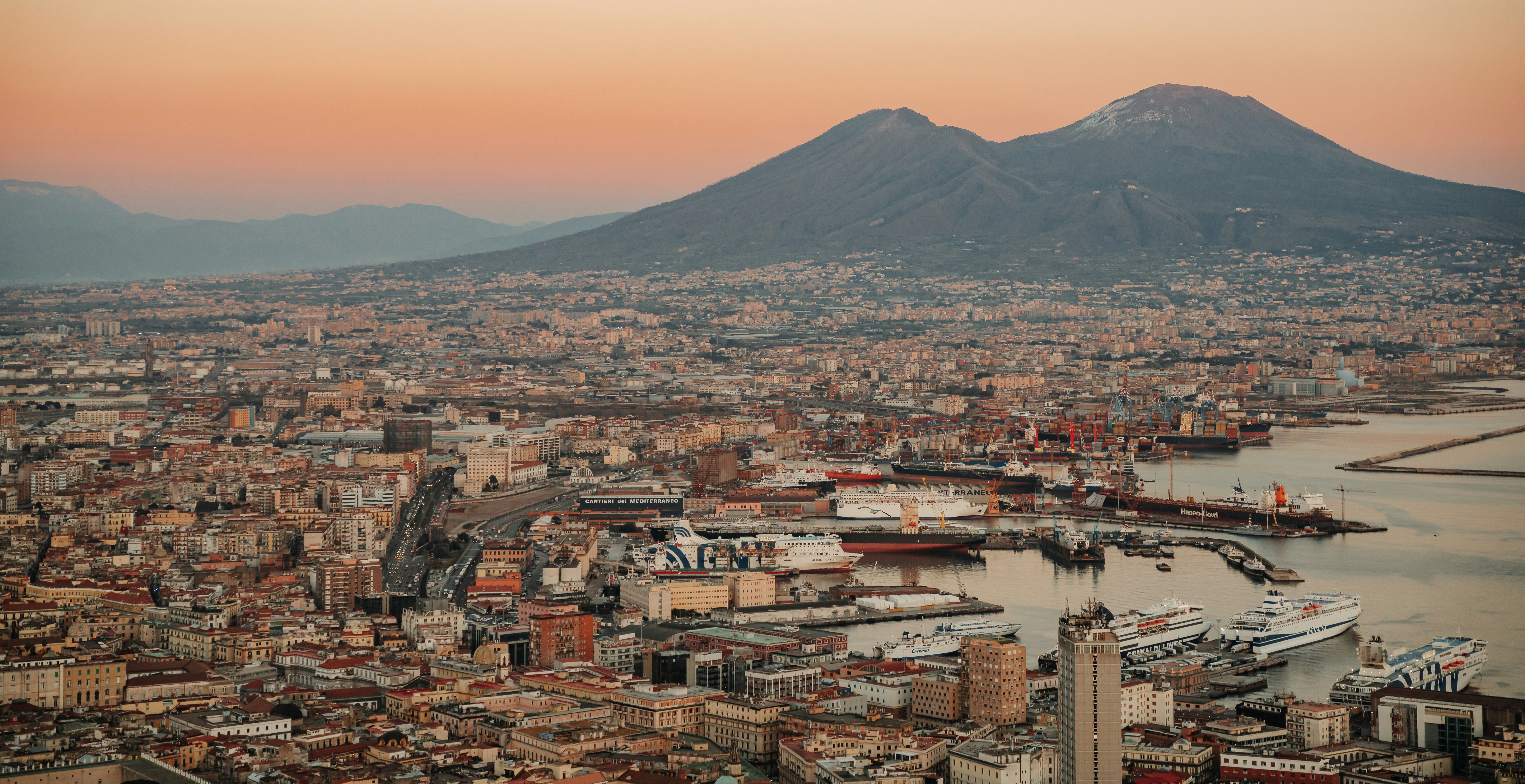
One of the most pressing issues in the geography of modern Naples is the logistical nightmare of what is known as “The Red Zone”. This is an area where an eruption would be so catastrophic that the only viable strategy is to evacuate everyone before it begins.
The challenge is: how do you move 600,000+ people out of the immediate danger zone and about 3 million out of the wider area when the infrastructure is a mix of high-speed motorways and winding alleyways?
One of the most direct solutions is simply to have fewer people in the way. The government offered financial incentives (grants of up to €30,000) for families to move out of the Red Zone and relocate to safer ground.
In practice, this has faced significant cultural hurdles. Many Neapolitans have a deep, ancestral connection to their land. Is money enough to make someone leave their heritage behind? This is something that students can analyse the success rate of firsthand.
Where do they go if they need to evacuate?
A common failure in disaster planning is focusing on the exit but forgetting the destination. Every municipality in the Red Zone is officially paired with a different region of Italy. For example, if you live in Portici, your designated safe haven is Piedmont. If you live in Pompeii, you are headed to Sardinia.
Coastal Geography and Sea-Level Change
Finally, the Bay itself is a masterclass in coastal morphology, the study of how coastlines evolve and are shaped by tides and wave action. It’s also a fantastic lesson on the impact of the "Bradyseism", which is the gradual uplift or collapse of the Earth's surface. This typically happens in volcanic areas due to underground magma or hydrothermal fluid movement.
In the town of Pozzuoli, between 1982 and 1984, the ground rose by nearly 2 meters. This not only caused earthquakes but also made the harbour too shallow for fishing boats, devastating the local economy.
Students can analyse how land-level rise versus sea-level rise affects coastal communities. It’s a rare chance to see land-level change happening within a human lifetime, rather than over millions of years.
A college or university geography trip to Naples and the Vesuvius threat
The centrepiece of any university geography trip to Naples is, undoubtedly, Mount Vesuvius. It is currently the only active volcano on mainland Europe and is frequently cited as the most dangerous in the world.
While the hike to the Great Crater is safe and well-managed, it serves as the perfect vantage point for students to practice professional fieldwork techniques, such as:
Analysing primary hazards
Students can look at the steep southern side and identify the natural channels where superheated clouds of ash and gas would flow. They can calculate the potential speed (up to 700km/h) and realise why evacuation must happen before an eruption begins.
By understanding wind patterns across the Bay, students can map out the "Yellow Zone”, which faces dangers from ash accumulation. Residents of the Yellow Zone may be evacuated during an eruption event if the conditions call for it. Students can discuss how even a few centimetres of volcanic ash can cause the collapse of roofs and other structures in a densely populated urban environment.
Evaluating secondary hazards
The threat doesn't end when the eruption stops. A geography tour to the Bay of Naples allows students to see the landscape that fuels secondary disasters. Looking toward the distant Apennine Mountains, students can see loose volcanic material from past eruptions. They can analyse how heavy rainfall (common in the Mediterranean autumn) can turn this ash into a liquid concrete substance, creating devastating mudflows that travel far beyond the Red and Yellow Zones.
How is Vesuvius monitored today?
A university or college geography trip to Naples is incomplete without visiting the Vesuvius Observatory, which uses a multi-parameter network to understand how eruptions or potential eruptions are predicted. The observatory uses three main scientific metrics.
Borehole tiltmeters
Borehole tiltmeters are installed in narrow wells, sometimes hundreds of meters deep, to avoid the noise of surface weather and the daily activities of people living in the area.
These sensors are so sensitive that they can measure a tilt angle of one microradian. One microradian is roughly the angle a 1km-long beam would move if you placed a single sheet of paper under one end. This super sensitivity helps detect volcanic inflation as magma moves into the plumbing system. If Vesuvius begins to show signs of activity, the tiltmeters are the first to know.
Satellite monitoring from space
The geography in Naples is not only monitored from under the ground, but also monitored from orbit. InSAR (Interferometric Synthetic Aperture Radar) uses satellites to bounce radar waves off the volcano’s surface.
By comparing two radar images of the same location taken at different times, scientists can create visual maps, or interferograms. These maps show millimetre-level changes in the Earth’s crust across the entire Bay of Naples.
Students can learn how this technology is used to differentiate between subsidence (the ground sinking naturally) and volcanic uplift caused by tectonic pressure.
Geochemical monitoring
Before a volcano erupts, it's often said that it starts “breathing”. This refers to the inflation (swelling) and deflation (subsiding) of a volcano as magma and gas move through its plumbing system. Sensors placed inside the Earth sample the gases being emitted from the Earth’s interior.
Scientists look for a change in the ratio of CO2 (Carbon Dioxide) to SO2 (Sulfur Dioxide). An increase in sulfur levels often indicates that magma is getting closer to the surface. Which is an indicator that there might be an eruption on the horizon.
Students can observe the steam vents where these gases emerge. They can discuss how geochemical early warnings can sometimes provide a longer lead time than seismic tremors, giving people extra time to initiate evacuation plans.
Historical case studies of volcanic activity in Naples
Napoli offers something that very few other destinations can: the ability to walk through history. While many see Pompeii and Herculaneum as purely historical, for a geographer, these sites are living evidence of what happens when human settlement meets extreme physical processes, and the correct procedures and measurements are not taken beforehand.
Pompeii eruption
Pompeii was a bustling commercial hub with a population of around 11,000 to 15,000. On the morning of August 24, AD 79, Mount Vesuvius erupted for the first time in over 800 years.
The eruption began with a massive explosion that sent a column of ash 30km into the stratosphere. Because of the prevailing wind, this debris rained directly onto Pompeii. For about 18 hours, ash fell at a rate of 15cm per hour. This created a primary hazard that students can still see evidence of through the structural collapse. In fact, most of the 1,000+ bodies found in the ash layers weren't killed by heat, but by roofs collapsing under the sheer weight of the volcanic stone.
The city was eventually sealed by the secondary phase, the pyroclastic surges, clouds of superheated gas and ash that moved at 100mph, instantly suffocating those who had taken shelter in their cellars.
Students are able to physically see the lapilli (stony fragments of volcanic material) layers in the unexcavated areas. They can see the clear layering of the eruption, which acts as a vertical timeline of the disaster.
Herculaneum eruption
Herculaneum was a coastal resort town of about 4,000 to 5,000 people and sat much closer to the base of the volcano than Pompeii, but to the west. During the first phase of the eruption, while Pompeii was being buried in ash, Herculaneum remained relatively clear because it was upwind. This gave many residents time to flee to the beach.
When the eruptive column eventually collapsed, a series of six pyroclastic surges flooded down the mountain. Unlike the dry ash of Pompeii, these surges were a dense, hot mix of volcanic mud and gas.
Herculaneum was buried under 20 meters of volcanic material (compared to Pompeii’s 4–6 meters). This mud hardened into a volcanic rock called “tufa”, which acted as a vacuum seal. Because oxygen couldn't penetrate this substance seal, organic materials like wood and food didn't rot. They were carbonised by the intense heat (over 400°C) and preserved perfectly.
Nowadays, in Herculaneum, students can actually see second-story wooden balconies and furniture that survived for 2,000 years. This allows for a brilliant comparison of how things are preserved between the two sites.
Turning theory into reality with StudyLink Tours
The geography present in the Bay of Naples is a complex, breathing example of the challenges facing our modern world. From the high-tech monitoring at the Vesuvius Observatory to the logistical puzzles of the "Red Zone," this region provides students with the critical thinking skills they need to become the geographers of tomorrow.
By choosing a college geography trip to the Bay of Naples, you aren't just giving your students an educational tour; you’re giving them a perspective on human resilience and the power of the natural world that will stay with them for a lifetime.
At StudyLink Tours, we specialise in creating bespoke, subject-led itineraries that handle the logistics, so you can focus on the teaching. From coordinating with expert volcanologists to arranging visits to the most relevant geographical sites, we ensure your trip is as safe as it is educational.
Don't just read about Naples geography, experience it. Whether you are looking for an A-Level hazard tour or a deep-dive university field study, our team is here to help you plan the perfect trip. Request a quote for your group or get in touch with us to find out more.